I
just want to reiterate, “be careful about swatting flies when Betty is looking
for a volunteer!” LOL – This is a travel day from Dease Lake to Stewart,
British Columbia (about 242 miles or 390 kilometers).
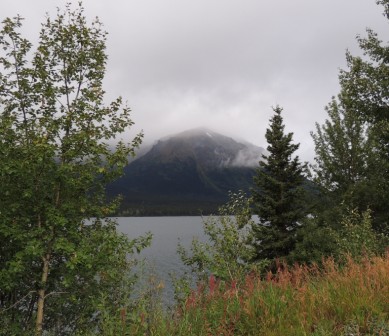
The
day started out dreary and misty. As we
traveled along Cassiar Highway and the Stewart-Hyder Access Road, we saw rain, clouds
covering the mountains, and then the sun peeking through. The road turned out
to be one of the best roads we have traveled on even though at times it was
curvy and narrow; but a good part of the road was freshly paved and we drove on
it as though it was a two-lane freeway.
 |
| Another view of the beautiful Mountains & Lakes |
 |
| Mountains looked like they were smoking for the fog |
Most
of the many bridges we crossed had wood surfaces rather than pavement. We still
were stopped by construction, and we saw more
mountains, lakes, and fireweed. The fireweed is now going to seed, but is
still majestic with its fiery red leaves. And let us not forget the many
waterfalls. If there is a mountain and a crevice, there is a long flowing
waterfall.
 |
Fireweed -- (When Fireweed goes to cotton, summer is
soon forgotten) |
 |
| Construction for the one lane bridge |
We
stopped for lunch at Bell II Crossing and delighted in the warm
soup and sandwiches. About 20 miles before arriving at our destination, we were
treated to a view of Bear Glacier. At our travel briefing at Bear River RV Park, everyone
but two reported seeing black bears during the day; some had as many as 6
sightings!
 |
| Bear Glacier |
 |
| Bell II Crossing |
About
6 pm most of us carpooled to Fish Creek Wildlife Viewing Area which is 3 miles
north of Hyder, Alaska; Hyder is next door (but across the border)
from Stewart. These towns are located at the head of Portland Canal, a narrow
fjord about 90 miles in length. Stewart boasts of being Canada’s most northerly
ice-free port.
 |
| Hyder Alaska |
Fish
Creek, operated by the U.S. Forest Service, has a raised boardwalk
for viewing the bears (both grizzly and black) as they fish for salmon in the
shallow waters of the creek. What a treat!
We saw many salmon in the crystal clear water; then we saw two bears at
separate times as they rustled in the bushes, splashed in the water, walked
along the creek and “hunted” for salmon.
 |
| Bear looking for another Fish |
 |
| Bear with Fish |
On
our way back to Hyder/Stewart we passed the grand yacht club of Stewart.
 |
| Grand Yacht Club of Stewart |
Submitted
by Rig # 13
 |
| Jim & Linda |


No comments:
Post a Comment